Flores is a beautiful island. It is extremely mountainous, with roads that wind in and around stunning ravines, smoking volcanoes, deep valleys, narrow rivers and lush plains. The name Flores means ‘flower’, and comes from the Portuguese. During the 1500’s many Portuguese involved in the sandalwood trade or religion came to Flores.
Geologically it is different to the island of Timor. Flores is primarily volcanic whereas Timor is limestone [coral] and clay, pushed out of the sea. Flores island is not all fertile and green, there are dry regions that are similar to the rest of NTT. Flores has many sandy beaches, excellent reefs and tiny uninhabited islands off the coast. It is an island of contrasts.
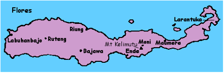
To get to Flores one can either take a boat or ferry, or fly. Labuhan Bajo on the western end of Flores is a small and somewhat wild port. Labuhan is short for pelabuhan in Indo-nesian and means harbour. The one main street is full of little restaurants, shops selling essentials, and visiting fishermen. The harbour at one end of the street is in a constant state of movement as boats, both small and large come and go. The coastal people of Flores obtain their livelihood from the sea. The view across the bay, back towards Komodo and Rinca Islands, is magnificent, especially at sunset or sunrise.
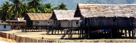
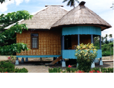
Travel on Flores is slow. Local buses traverse the 688 kilometres of road that snakes across the island. The only other way to do it is by private hire car or mini-van. It is a four to six hour drive from Labuhan Bajo to Ruteng, high in the highlands. Lush and cool, Ruteng is the home of the Manggarai ethnic group. Their weaving is recognisable by its very dark colours, particularly black, and distinctive patterns used. Their houses are also very distinct with a very tall roof on a circular base.
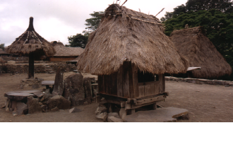
Twelve kilometres out of Ruteng is a deep lake known as Danau Ranamese. Travelling on from Ruteng another four to six hours one comes to the mountain town of Bajawa. Bajawa is home to the Ngada ethnic group. The people of Flores are predominantly Catholic (86%). Traditional animistic practises are mixed with Catholicism. Bena is a traditional village 18 kilometres out of Bajawa. It is an example of this mix at work. The people call themselves ‘good Catholics’, but continue to strictly observe ancestor worship.
Bena is at the base of Inerie Volcano which is more than 2 kilometres above sea level. The houses are set in a long line either side of a central area used for graves and ancestral shrines. The ancestral shrines are in two forms: the ‘male’ ngadhu and ‘female’ bhaga.
About every 50 years a new pair of ngadhu and bhaga are built. Many costly ceremonies accompany this event. At one point, several men must stay inside the bhaga until a buffalo can be sacrificed. This was the case when we visited Bena. With the economy crash of 1998 the village had been unable to raise sufficient funds to obtain a buffalo, and men had been living in the hut for several weeks.
When a ngadhu is built, underneath it is buried a chicken, dog and pig. On the roofs of the leading houses in the village are placed small replicas of the ngadhu, according to what clan you are in.
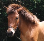
Flores, like Sumba, is known for its small and sturdy horses. They are very handy for travel and transport up and down the steep mountains. They are also used in ceremonies, particularly amongst the Ngada hill people. When a house is to be built for example, a horse is slaughtered to ensure success.
On the North coast of Flores is a small fishing village called Riung. Riung is well known because of the 17 Island Sea Gardens. Off the coast of Riung are a number of small islands surrounded by beautiful coral reefs. There are excellent places to snorkel and dive. There are not actually 17 islands, but it was so named by the government after Indonesian Independence Day on 17 August. Riung is also the home of a special breed of giant iguana very similar to the komodo. These brightly coloured animals inhabit one of the islands off the coast.
The northern coastal plain is quite dry compared to the rest of Flores. There are numerous settlements of transmigrants along the less fertile coast. These migrants come from islands such as Bali, Java and South Sulawesi which are too densely populated.
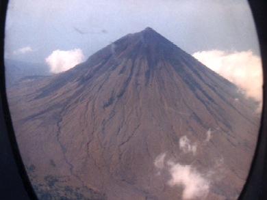
Ende is the next major town along the route to East Flores. This drab town used to be a major port and some families claim to have descended from the Majapahit Kingdom of Java. Ende is on a narrow peninsula with two volcanoes towering over the town.
It is about a two hour drive from Ende to the mountain village of Moni. The main street of Moni is one long winding road lined with small losmens, hotels, shops and restaurants. Moni was affected by the violent earthquake that hit Flores in December 1992. Both the local high school and large Catholic Church were partly destroyed.
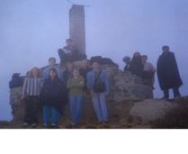
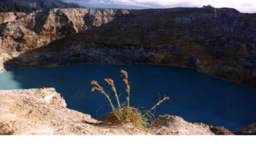
Moni is a favourite place for tourists to stay. It is cool, with delightful mountain scenery and the famous 3 coloured lakes are nearby. It is a 4am truck ride that winds up 13 kilometres to the base of the three volcanic crater lakes known as Kelimutu. Tourists and locals rugged up in warm woven sarongs make the pilgrimage to the top to view the sunrise. It is a cold, dark and mist covered dirt path that is followed until the trig point. As the sun rises everyone hopes that the biting wind will take the mist and clouds away so that the lakes and surrounding district can be seen.
The lakes frequently change colour, and no-one is sure why. There is a local legend that says the black lake is where souls of murderers and thieves go. The turquoise lake is for the souls of old people, and the greeny-coke coloured lake is for young people’s souls. Instead of taking the truck back to Moni around 7am, one can leisurely walk down the road and take a short cut through several villages to arrive at a waterfall above Moni. This is well worth doing.
It is about four hours drive through rugged scenery from Moni to Maumere. Maumere is quite a large commercial centre with the island’s main airport. This area is home to the Sikka ethnic group. Just out of Maumere along the coast is a number of large tourist resorts. Off Maumere there are beautiful coral reefs, and plenty of beaches to enjoy.
Larantuka is the last major town in eastern Flores. It is a small port with close links to Solor, and a strong Catholic and ritual tradition.
Questions / Activities
1. Explain the origin of the name Flores.2. Draw a map of Flores, label each place, and draw a picture to represent it.
Extra Activities, Comprehension, Discussion and Research Questions
1. Make a paper mache model of Kelimutu - paint it the correct colours.
2. Make a paper mache model of a volcano. Ask your science teacher to show you how to make it erupt.
3. Contrast the geological formation of Flores and Timor. How has this influenced the type of vegetation on the two islands?
4. Find net sites about volcanoes. Find a) sites about formation of volcanoes appropriate to teach junior classes, b) look for sites on Indonesian volcanoes such as Semeru, Merapi, Tangkuban Perahu, Krakatau, Bromo, Batur, Agung and Rinjani.
5. Draw several different houses from Flores into your book and label which region they are in. You will need to look at Module 4 for help with this question.
5. Using the map showing Kabupaten (Regencies) of NTT, find out how many regencies there are on Flores (see Module 2 for the map). Make a list of their names, and write beside these the major town that is in that regency.
6. Are there active volcanoes on Flores?
7. When did the Portuguese arrive in Flores and why?
8. True/false Questions:
a) Flores is primarily volcanic.
b) Flores means rose.
c) Sandalwood is a herb.
d) Ruteng is home of the Manggarai people.
e) Flores is primarily Moslem.
f) Horses are used for animal sacrifices.
g) A ngadhu is a place for Catholic worship.
h) Ende sounds like an exciting town to visit.
i) Bajawa is on the west coast.
j) Kelimutu consists of three blue lakes.
k) The Sikka people are from Maumere district.
l) There are good reefs off the town of Maumere.
m) Larantuka is a major town in western Flores.
9. Describe the role of horses on Flores.
10. Which other island in NTT is well known for its horses?
11. Do the people of Flores do weaving?
12. Where is the dryer region of Flores?
13. Some of the volcanoes mentioned in the activities section have legends associated with them, for example Kelimutu or Batur (made by the giant Kbo Iwo). Research one. Write it out. Form groups to do this and then turn them into plays to be performed for the rest of the class ... so they also will know of the legend.
14. Research information about the iguana found near Riung. Draw a coloured picture of one and list relevant details concerning its daily life.
15. Using a tourist guide like Lonely Planet or Indonesia Handbook, write out a plan for a two week holiday to Flores. List places to visit and things to be done while there. Also note down accommodation and prices. Pay particular attention to how much time you will need to use for travel.
16. Write to the Indonesian Embassy or Consulate and see if they have any information they can send you on NTT or Flores in particular.
17. What is transmigration? After class discussion, write arguments for and against transmigration. Why do you think transmigrants are located on northern Flores?
18. Research the early settlement of Portuguese on Flores. Why were they first on the eastern coast?
19. When was Majapahit Kingdom in Java? Why would there be people descended from this kingdom living in Ende?